

Washington DC Metro
Families on the silver line..
Available free on iOS and Android
Easy routing
A simple and quick journey planner
tourists at Washington Monument.
See every step.
Important station highlights on the metro map
commuters going home.
Make it your own.
Save your Home and Work stops.
Washington DC Metro map and route planner
The easy-to-read map and useful journey planning tools are the best way to guide yourself around the city. Let Washington DC Metro plan your journey to the Lincoln Memorial, the Smithsonian or to that coffee place near Union Station you visit before work.
Clear Metro Map
We’ve given our Washington DC Metro app the clearest and most user-friendly map on the market. By making a few tweaks to the official metro map our users tell us it’s much easier to read when getting from A to B.

Route Planner
In the route planner you’ll find both metro stations and points of interest, making it even easier to get exactly where you to need to go. Locations like Pentagon City, Ford’s Theatre and the National Portrait Gallery are all a click away and Washington DC Metro will find you the quickest and simplest routes.
– Did You Know? –
It’s illegal to eat in the DC metro facilities. Eating, drinking or littering could land you in trouble and result in a large fine!
Step-By-Step Guides
It helps to have an itinerary but sometimes it can be difficult to picture where you will be in relation to the map. That’s why our handy transport app gives you step-by-step guides on the metro map itself. Each journey is broken down so you know every direction and every changeover.
Available free iOS and Android
Your stops on multiple devices.
Save your Home and Work stops as well as your favourite journeys so that they’re there for you when you need them. Find them on any device when you log-in, available on iOS, Android and web .
– Travel Tip –
When using an escalator stand on the right, leave the left side free for “moving traffic”.
Washington DC Metro review on iTunes
Imzadi1701 | 10th december 2017, beaclavijo | 29th october 2017, m.lovanisci | 6th october 2017.
For a better chance at getting a seat, get on the front carriage where it tends to be quieter.
It may sound obvious but when a train is packed, it sometimes pays off to just wait for the next one.
Additional Features
Nearby stops.
This is the quickest and easiest way to start your journey. Washington DC Metro uses your location to find the nearest station to you and automatically selects it.
Walking Shortcuts
An overlay that reveals where on the map it’s quicker to walk between stations rather than use the subway.
Removes Ads
Remove the adverts with a simple one-off purchase.

- Travel Guide
- Recommended Hotels
How to Ride DC Metro: 10 Dos and Don’ts
Every visitor to Washington, DC should brush up on how to ride DC Metro. There are a lot of written and unwritten rules, but don’t worry, follow these dos and don’ts and you will become a Metro pro in no time.

1. Do get a SmarTrip card
This used to be a suggestion but now it is a requirement. If you visited DC prior to 2016 you probably paid for the Metro using a paper fare card. It was a piece of cardboard, had a couple cute pandas on it, and would print your balance on the card every time that you used it. Go ahead and put it in a scrapbook because you’re not going to need it anymore. The good news is that SmarTrip cards are just as easy to get at the old paper fare card.
When you arrive at your first Metro station look for one of the orange and blue colored fare machines. You’ll need to decide if you want a single fare card or multiple. If you’re traveling with a family, you will need multiple cards. Unlike in other cities, every person in the group needs their own SmarTrip card. Then you’ll need to decide if you want to add money or buy a pass.
For a typical tourist we recommend starting off by adding the $8 default value and topping up your card as you go. Unless you’re going to ride the Metro all the time a pass probably isn’t worth the money. You can pay using either cash Or credit or debit card. Try to use exact change if you have it.
Once you’ve got your card, walk up to the fare gate, tap it against the target and go through once it opens. When you get to your destination you’ll do the exact same thing to exit.
2. Don’t stand on the left
This is probably the single most important piece of advice you’re going to get when it comes to how to ride DC Metro. When you’re riding a Metro escalator, never, ever stand on the left side. If you’re walking you walk up on the left side and if you’re standing you stand on the right side. Simple enough!
One of the reasons why tourists get such a bad reputation among locals here is because they don’t follow this simple rule. On a similar note, if you’re coming from the airport or Union Station when you’re riding the escalator, put your suitcase in front or behind you. That way if someone’s trying to walk up they’re not going to get blocked by your luggage. Or find an elevator and use it.
3. Do download a Metro app
There are a lot of Metro apps out there and people have varying opinions on which one is the best. Some apps have more bells and whistles than others, but at the end of the day they all basically do the same thing: tell you how long you have to wait for your train.
Yes, there are electronic boards in every station that technically give you this information; but they have a really annoying habit of scrolling through a bunch of announcements when all you’re really looking for is the amount of time until the next train.
Our favorite Metro app is called MetroHero . Regardless of which app you choose, just make sure you also download a jpeg of the Metro map to your phone. That way if you’re in a tunnel, or you have spotty service you will always be able to access the map even when you’re online.
4. Don’t ride during rush hour
There are two reasons to avoid riding the DC Metro during rush hour.
First, it actually costs more money to ride Metro during rush hour than it does at any other time. That’s because metro fares are based on the distance that you travel and whether it’s rush hour or not. More importantly, DC is a working city and people commute so it gets slammed and can feel pretty miserable to ride during rush hour.
5. Do plan for delays
A lot of people come to DC absolutely love our Metro system. Typicall that’s because it is so much better than what they have back home. That hardly means that it’s perfect though and the truth is that Metro is in pretty bad shape. Unfortunately, some locals now consider Metro unreliable.
So if you have tickets to an event, dinner reservation, or a scheduled tour, just plan to arrive a few minutes before it’s supposed to start. It’s much better to arrive early than it is to be disappointed because Metro let you down.
6. Don’t block or hold the doors
Other than standing on the left this is one of the biggest offenses that someone can make on the Metro. The important thing to know is that Metro train doors are not like elevator doors. You can’t hold them open by putting your hand in. And if you do try to hold it open the door is going to close right on your arm. Metro operators usually try to get the doors closed a few times before they eventually give up and kick everybody off the train. Trust us, you don’t want to be the one who inconvenienced hundreds or even possibly thousands of travelers because you messed with the doors.
7. Do wait for people to get off the train before you try to board
When a train pulls into the station and you see some empty seats it is tempting to rush in as fast as you can and grab them before anybody else can. However you really need to wait until everybody is off the train first before you can try to get on. Metro doors are not very wide and it becomes a huge mess when people aren’t even off the train yet and other people are already rushing into the car. So just have a little patience you’ll get on the train. Don’t worry.
8. Don’t wait for the fare gates to close in front of you before you go through
This trip hack is particularly useful during rush hour or after a game or any other busy period when there are a lot of people trying to move through the Metro at the same time. All you have to do is stand behind the person in front of you who’s going through the fare gate. Once they’ve tapped their SmarTrip card, tap yours and go on through. You don’t actually have to wait for the gate to close before you can tap. Doing it this way will save a lot of time. Locals will also really appreciate that you’ve been clued in to this little hack.
9. Do avoid transfers and bad routes
Sometimes transfers are unavoidable and that’s OK. But a lot of times people actually make unnecessary transfers. A lot of the problem stems from the fact that the Metro map is not to scale. It doesn’t help that some stations have names that are confusing and make you think you need to use one station when you should really use another.
Say you want to ride the Metro from U Street to the Air and Space Museum. A lot of folks would look at the Metro map, ride the green line to L’Enfant Plaza, transfer to the Orange, Blue, or Silver lines, then get off at the Smithsonian station. This is a total rookie mistake! The walk from the Smithsonian station to the Air and space Museum is actually twice as far as the walk from the L’Enfant Plaza station, not to mention the time that you wasted making a transfer to a line and riding a train that you didn’t have to.
This is the reason why apps like Citymapper are so helpful. They do all the work for you. So, you don’t need to know all this information to figure out which station is actually closest to the destination where you’re trying to go.
10. Don’t stop at the top of a Metro escalator
It can be disorienting when you are at a new Metro station in a new neighborhood. The first thing you want to do when you get off the escalator is pull out your phone and use Google Maps to figure out where you are. But people are still coming up the escalator behind you and if you don’t move you’ll cause a pileup!
It’s totally fine if you need to check your surroundings once you get off the Metro. However, make sure to walk a few yards away from the station and away from the escalators before you take out your phone or take out your map to figure out where you are.
Coming to Washington DC and want us to show you around? Trip Hacks DC was founded by Rob, a veteran tour guide in the Nation’s Capital. Trip Hacks DC provides tips, tricks and travel hacks for planning your trip; and guided tours to show you around once you get here. Our tours are family and school group friendly and our guides specialize in the major Washington, DC sites. Click here to check out the upcoming tour options and to book your tour here today! Feel free to contact us if you have any tour questions.
Book a Tour!
Private Tour with Rob Monumental Trivia Tour Historic Georgetown School Group Tours
About Trip Hacks DC
Trip planning resources.
- DC Airports: a Guide to Navigating DCA, IAD and BWI
- The Ultimate Washington DC Travel Guide (2023)
- Hotels in DC: A Guide On Where to Stay
- The 5 Best Local Washington DC Tours
- Washington DC Trip Planning: Trip Hacks DC E-book
- Packing for Washington DC: What To Bring for Your Trip
Newest Podcast Episodes
- Podcast Ep.58 Tips for Attending Pro Sports in Washington DC
- Podcast Ep.57 Everything Visitors Should Know About Washington DC Cherry Blossoms
- Podcast Ep.56 Managing Your Washington DC Travel Expectations
- Podcast Ep.55 What to Expect for Washington DC Tourism in 2024
- Podcast Ep.54 Every Holiday in Washington DC
- Podcast Ep.53 Why I Don’t Recommend Airbnb in Washington DC
- Podcast Ep.52 Washington DC Experiences to DO and SKIP
- Podcast Ep.51 Rob’s Washington DC Travel Philosophy
Proceed Booking
Already a member.
Username or E-mail
Forget Password?
Don't have an account? Create one.
Or continue as guest.
DC's system is relatively straight forward and easy to use, but we've compiled some of the most frequent questions that we hear about riding and navigating the DC Metro system.
Navigating Metro
How do I get to my destination?
Within Washington DC and the nearby parts of Virginia and Maryland, there are many transportation options, including Metro (DC's subway system), MetroBus , and taxis. Additionally, downtown DC can be reasonably walkable. Getting to your destination can involve one or many of these modes of transportation. Since you're on this site, you're probably interested in public transit.
There are a couple good ways to find a route. If you happen to know the neighborhoods that you are traveling from and to, and they have metro stations, just take a look at our DC Metro Map . If you don't know exactly where things are, or don't know if you have metro service, Google Maps provides a great service. Type in an starting and ending address or attraction and get transit, walking, and driving directions. Both Metro and MetroBus routes and schedules are included in their routing system, and it even takes care of computing transfers and optimal routes.
Finally, WMATA's trip planner can be useful. It isn't as visual as Google Maps, but it includes information about fares and travel times.
What will my trip cost?
Trip costs vary by starting and ending locations, time of day, and payment method.
There is an additional charge during metro's busiest hours: weekdays from opening to 9:30 am and 3-7 pm and weekends midnight to closing, and using a paper FareCard instead of a SmarTrip card incurs a dollar surcharge on each trip.
For exact fares, use WMATA's trip planner .
Do children ride for free?
Up to two children age four or younger may travel with a single adult for no charge. Children 5 or older must pay the usual rate.
How do I get to Georgetown?
Georgetown is a popular destination in Washington DC, as home to Georgetown University, the Georgetown Waterfront, and many small shops and restaurants, including the famous Georgetown Cupcake. While popular, the neighborhood is not serviced by the Metro system, leaving visitors with a limited set of travel options.
- Bus or walk from Rosslyn Station ( Blue Line and Orange Line ). Rosslyn is a neighborhood in Arlington, Virginia, and provides the shortest walk (about 15 min) to Georgetown from a metro station by crossing the Key Bridge (the bridge is north of the metro station). There are also bus routes to Georgetown from this location, and the Georgetown University shuttle stops at the station for those with access.
- Bus or walk from Foggy Bottom Station ( Blue Line and Orange Line ). A bit further than Rosslyn, this station provides about a 25 minute walk and additional bus routes which service Georgetown.
- Bus from DupontStation ( Red Line ). For riders of the red line, Dupont Circle likely offers the most direct bus routes to Georgetown.
- Take the Circulator Bus. The circulator is a set of bus lines which service popular areas and attractions in DC, including Georgetown.
In general, we suggest using Google Maps to find the best bus route.
How to I travel from National Harbor to Washington DC?
National Harbor is not directly metro accessible, but there is a Metrobus line, NH1 which provides access to Branch Avenue, a station on metro's green line. Instead of bus, you can also drive to Branch Avenue station (about 12 minutes with light traffic) or Huntington station on the yellow line (about 9 minutes with light traffic).
System Information
What is the current status of track work and system delays?
You can find Metro 's track work information here , and current alerts and advisories here .
Why is there so much track work on the weekend and holidays?
While convenient for weekend fun in the city and tourists visiting DC, the vast majority of Metro 's usage comes from commuters traveling to and from work Monday through Friday. While delays and bus service replacing rail is annoying for anybody who happens to be riding, this would have a much much more profound effect during the workweek. (Delays during rush hour due to mechanical issues have been known to cause crowed platforms, massive numbers of complaints, and lots of business for nearby taxis).
What is single tracking?
The rail lines in the Metro system primarily consist of two sets of parallel track, one dedicated to each direction of travel. During maintenance or malfunctions, it is sometimes necessary to route all trains on a single one of these tracks to move trains around an issue. This can happen between two stations, or for several stations, depending on how large the effected area is, and whether there are locations where trains can switch tracks. This process is known as "single tracking" and can create some delays as trains must wait for the effected area to be clear of trains traveling in the opposite direction.
When is the first / last train to a station?
During the middle of the day and rush hour, Metro trains don't typically maintain a consistent schedule; instead, they typically maintain a reasonable frequency. The first and last trains to each station, however, do try to maintain a schedule. The timetable for trains can be found here .
What stations provide parking? What does it cost?
WMATA operates several parking lots and garages in tandem with Metro stations. For a list of stations with WMATA lots, see the our page on the five Metro Lines . Clicking into an individual station will provide additional information about cost and lot size.
There are many other parking garages in and around Washington DC. While we do not list them extensively, we recommend using a site such as parkme.com for your search.
Is overnight or long-term parking available? Most WMATA run parking lots and garages do not allow overnight or long-term parking. The exceptions are Greenbelt Station , Huntington Station , and Franconia-Springfield Station . These stations each have a limited number of spaces (15-17) available for first serve parking of up to 10 days, and charge the usual daily rate.
As with parking in general, there are many other parking garages in and around Washington DC, many of which allow long-term parking. While we do not list them extensively, we recommend using a site such as parkme.com for your search.
- Advertising
Washington Metropolitan Area Transit Authority
Metrorail and metrobus are the safest, cleanest and most efficient ways to get around washington.
Metrorail and Metrobus are the safest, cleanest and most efficient ways to get around Washington. Five rail lines and extensive bus service connect Washington, DC with Maryland and Virginia suburbs. Train lines are named for colors: red, yellow, blue, green, and orange. Station entrances are marked by brown pylons, capped with the letter M and colored stripes indicate which lines are available in that station. Metrorail route maps are posted in each station and inside each subway car. Metro opens at 5 am, Mon. - Fri. and 7 am. on Sat. and Sun. Metro closes at midnight Sun. - Thur. and 3 am Fri. and Sat. Base subway fare is $1.95 and increases during rush hours and for longer trips. Rail farecards are inserted into the turnstile gates to enter and exit subway platforms. The fare is automatically deducted each time you exit a station. For an interactive trip planner for bus and rail, use The Trip Planner on the website at MetroOpensDoors.com or call customer information at (202) 637-7000. For advance farecard purchases, convention passes, group sales call (202) 962-5700, 202-962-5716 or 202-962-5722. Farecards may be purchased from vending machines in all Metrorail stations.
Additional Information
Cities served.
Virginia, District of Columbia & Maryland
Airports Served
600 5th st. nw marketing washington , dc 20001 united states, (202) 637-7000.
View Gallery
Nearby Favorites
Big bus tours washington, dc.
Explore the Nation's Capital on Big Bus Tours, the official tour ...
Waldorf Astoria Washington, DC
An Iconic Address For An Unforgettable Stay
Monuments by Moonlight Night Tour
See DC In A Different Light! The Monuments by Moonlight Tour knows jus...
DC Metro Map, Navigating Washington, DC with Metro
Washington DC’s metro system is the economical and convenient way of transportation for both locals and tourists to move around the nation’s capital, including Maryland and Virginia. If you are a visitor and want to get an overview of different metro stations and nearby tourist attractions such as the US Capitol Building, Washington Monument, National Mall, White House, etc., then you need an interactive metro map.
Here’s the updated version of the DC metro map. With this map, you can easily navigate around the city, plan your trips, and reach your final destination without getting lost. Let’s take a deep dive into the high-resolution Washington metro map with streets and explore its different routes and stations.
DC Metro Map, Click to Enlarge

Washington DC Metro Routes

How Does the DC Metro Map Work?
The DC metro is the busiest transportation network, with over 355,000 weekday entries recorded by 2023, according to WMATA . The metro network consists of six color-coded lines: Orange Line, Red Line, Silver Line, Blue Line, Green Line, and Yellow Line. There are a total of 98 stations indicated by small circles on the map, and 128 miles of track. Potomac Yard is the most recent station added to the metro network on May 19, 2023. Many stations are accessible by more than one line sharing track with each other. For example, if you are planning a visit to the White House, then the closest station to it is the Federal Triangle, accessible by three lines. The following table shows different lines sharing tracks between different stations.
Different metro lines are connected with the help of transfer stations(that allow you to change from one route to another), indicated by a double circle on the map. The metro network consists of 8 transfer stations. For example, to travel from Capital South station to the Zoo, you would need to take the silver, orange, or blue line to Metro Center station. From there, transfer to the red line and continue to the Zoo. Here’s the list of different transfer points:
- Fort Totten (Red, Green and Yellow)
- Metro Center (Red, Orange, Silver, and Blue)
- Rosslyn (Orange, Silver and Blue)
- East Falls Chruch (Silver and Orange)
- L’Enfant Plaza (Yellow, Green, Blue, Silver and Orange)
- Stadium-Armory (Orange, Silver and Blue)
- Pentagon (Yellow and Blue)
- King St-Old Town (Yellow and Blue)
While reading the map, the line on the top of the other lines shows it is physically on the top floor. For example, at the Metro Center station, the red line is upstairs and the blue, silver, and orange lines are downstairs. WATMA metro trip planner is the most convenient way to plan your trip around the capital. The other transit networks are easily accessible by Metrorail, including Dulles International Airport, Ronald Reagan Washington National Airport, Baltimore Washington International Airport, and train services like MARC and Amtrak.
The following video will further guide you on how to read the DC Metro Map. Video credit: Trip Hack
Washington DC Metrorail Time Schedule
Metro trains run every day, but the timing may vary depending on specific lines and weekdays. However, in case of public holidays and special events, the metro’s regular operating schedule is modified. The Metrorail stops running at 12 AM, except on Fridays and Saturdays when it runs until 1 AM. The following table shows the rail hours for the whole week:
Now, how much the fare will be between the Washington DC metro stations? If I want to travel from Metro Center station to Rosslyn station, how much will it cost? The cost of the ticket depends on the length of the ride, the time you ride, and the day of the week. For details information about metro fares and how to buy tickets visit the page Fare and Tickets .
In this article, we comprehensively covered everything about the Washington DC Metro Map, which will help you in navigating the capital and planning your trips during your stay. We recommend using our interactive metro map during your journey and downloading a copy of the DC metro map on your phone. If you have any questions don’t forget to comment.
Frequently Asked Questions (FAQs)
There are six metro lines in Washington DC: Red, Green, Yellow, Orange, Silver, and Blue
In densely populated areas, tracks are underground while in suburban tracks are elevated or at the surface.
The DC metro is designed for a top speed of 75mph, but the average speed of the metro is 33mph.
The DC metro closes at 12 AM on Monday-Thursday and Sunday, but on Friday and Saturday, it closes at 1 AM.
Traveling on the metro is super easy! you will need a SmarTrip physical card or its mobile application. For detailed information about SmarTrip, visit the page Fare and Tickets
The metro Silver Line is directly connected to Washington Dulles International Airport, following the sign of metro from the airport terminal you can easily get to the metro station.
The Ronald Reagan International Airport can be accessed by Metro Yellow and Blue lines.
There are a total of 98 stations in the DC metro network
The Metro Center station is the nearest station to the White House, Pentagon, and Washington Monument.
Washington DC Metro Guide and Route Planner 4+
Discover ukraine llc, designed for ipad.
- 5.0 • 2 Ratings
- Offers In-App Purchases
Screenshots
Description.
The Washington Metro Guide is the quick and easy way to navigate your way into and around the city using the rapid transit system service. Key features: - Accurate and up-to-date metro maps - Quick and convenient route planer with travel time and distance information - Exact trip cost calculator - Find the nearest metro station to you using the Augmented Reality function - Useful information about routes, prices and payment options - Integrated Google and Apple Maps according to preference (offline map available to download separately) - Works offline - Real-time airport arrival and departure updates.
Version 1.6
This app has been updated by Apple to display the Apple Watch app icon. With this update we’ve added several new features that you requested and fixed some minor bugs. - The “favorites” function was added. Now you can save desired itineraries and view them in your favorites anytime. - More detailed information about metro lines has been added to the metro scheme. - Line transfer information was added in the itinerary description. Thank you for using our apps. Nothing makes us happier than to hear your comments and ideas. You can always share your feedback in the contact us form available in the app.
Ratings and Reviews
Nice as far as it goes..
Needs bus/rail connections, times for departure and arrival planning. Needs all bus info.
App Privacy
The developer, Discover Ukraine LLC , has not provided details about its privacy practices and handling of data to Apple.
No Details Provided
The developer will be required to provide privacy details when they submit their next app update.
Information
English, French, German, Italian, Japanese, Portuguese, Russian, Simplified Chinese, Spanish, Turkish, Ukrainian, Vietnamese
- Offline Map $0.99
- App Support
More By This Developer
Metro Transit with Offline Map
Perfect Currency Converter
Kyiv Metro Guide and Route Planner
Flight Board - Live Timetable
Ukrainian Cuisine & Recipes Guide
Hong Kong Metro Guide and MTR Route Planner
You Might Also Like
Washington Subway Map
KickMap Washington DC Metro
Explore Nash County
Provence’s Best: Travel Guide
National Mall Edition
National Gallery Full Edition
COVID-19 Updates
Vaccine and Booster Information
Reopening Guidelines
Plan your trip with
Plan your trip while at home, work, or on the go!
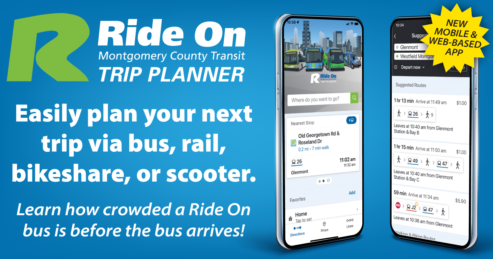
Metro's Trip Planner provides information on service for the entire Washington metropolitan area including Maryland, DC and Virginia.
These tools are constantly being improved and may not always provide the best solution for your trip. You may prefer to contact the MC311 Information Center for additional assistance by dialing 311 within Montgomery County or 240-777-0311 from outside the County.
- When snow, storms or other special circumstances occur that affect Ride On's ability to follow normal weekday schedules, bus service may operate under the 'S' Service Plan / 'S' Service Plan - en español.
- See bus service from Metrorail stations
Google Maps now includes Ride On transit route and schedule information. Use Google maps as you normally would but select "By Public Transit" to use public transportation for your trip. You can also select a future date and time by clicking the "Show options" button. Metro service is also available on Google Maps so your trip planning request will show connecting Metrobus or Metrorail service.
Get the Google Maps app for your phone or tablet .
MyMontgomery can help you locate bus stops near an address or County service locations and provide links to bus schedules serving those stops.

Lose an item on a Ride On bus? Contact our Lost & Found .
Washington, DC
Plan your trip by metro.
More Resources
Metro releases proposal for major changes to its bus system
by Tom Roussey

WASHINGTON (7News) — For over a year, Metro leaders have been working on a plan to make major changes to the bus system, and Tuesday for the first time Metro has put out concrete plans for what changes they are proposing.
The “Better Bus Network” proposal involves many things riders are likely to embrace – more service during off-peak hours and weekends, more service to places like hospitals, schools, and grocery stores, plus more service to fast-growing areas like National Harbor.
RELATED: Metro to increase fare but avoids most cuts starting July 1
But Metro warns trade-offs may have to be made, and while many people would benefit, some riders may not be happy.
For instance, some riders must go longer distances to get to a bus stop to make bus service faster and more efficient. Also, bringing more service to off-peak hours and weekends would reduce service at peak hours. In addition, some areas with low bus ridership could see a reduction or elimination of bus service.
To see Metro’s proposal for its “Better Bus Network,” you can click here .
To see if any changes are proposed for your bus route, start at page 55 from the document linked above. To see images of new proposed bus routes, start at page 34.
If enacted, the changes to the bus system could begin in the spring or summer of next year.
IMAGES
VIDEO
COMMENTS
Metro news and service information for the Washington, DC, Maryland, and Virginia region.
DC Metro trains run Monday - Thursday, 5 a.m. until 12 a.m.; Friday, 5 a.m. until 1 a.m.; Saturday: 7 a.m. until 1 a.m.; Sunday: 7 a.m. until 12 a.m. Metro etiquette. The Washington, DC Metro serves thousands of commuters and visitors each day. Because the train system is so heavily used by busy local commuters, there are a number of unspoken ...
About this app. Washington DC's number one public transit app, with realtime and schedule information for Metro rail, WMATA/Metro bus, Arlington Transit (ART) and DC Circulator. Plan your trip in the Washington Metropolitan region, including DC, Northern Virginia and Maryland. Realtime rail predictions for all DC Metro stations.
A Metro train leaving the station platform. (Photo by Teo (CC BY-SA 2.0)) Washington DC's Metro system is a great way to get to hundreds of popular locations and attractions in and around Washington DC. Metro's six lines and 91 stations are located in Washington DC and neighboring Virginia and Maryland. With over 700,000 trips every weekday ...
The first step to planning your trip is the DC Metro Map. Find the stations near your destination and learn about the Metro System on DC Transit Guide's Metro Map. Metro Lines. Explore Metro's six lines, and plan your route. Select individual stations to view live next train predictions, learn about nearby attractions, and see parking details ...
9 minutes. Live Map. Detail. A free app for WMATA DC Metrorail commuters. Real-time interactive line maps, expanded station train ETAs, and more.
Take our apps with you, just search Mapway on App Store. Washington DC Metro VIP available as an in-app subscription: $1.99 monthly or $4.99 annually, or as a one-off purchase of $12.99. Prices may vary by location. Cancel at any time, for any reason. Payment will be charged to your iTunes Account at confirmation of purchase.
Washington DC Metro map and route planner. The easy-to-read map and useful journey planning tools are the best way to guide yourself around the city. Let Washington DC Metro plan your journey to the Lincoln Memorial, the Smithsonian or to that coffee place near Union Station you visit before work.
NEWS. COG, Metro launch historic initiative, DMVMoves, to create a unified vision and sustainable funding model. Metro improves faregate display screen messaging to streamline customer experience. Metro Board approves $4.8B budget. Metro and transit partners announce travel alternatives for summer Red Line closure.
About this app. DC Transit uses the Washington Metropolitan Area Transit Authority (WMATA)'s real time data to get you DC Metro and Bus arrival times. Trip Planner available (Plan your trip around Washington DC & Baltimore. WMATA, DC Circulator, Arlington Transit (ART), DC Streetcar, PG County, Maryland Transit, Fairfax CUE and UMD Shuttle ...
How to Ride Washington DC Metro. 1. Do get a SmarTrip card. This used to be a suggestion but now it is a requirement. If you visited DC prior to 2016 you probably paid for the Metro using a paper fare card. It was a piece of cardboard, had a couple cute pandas on it, and would print your balance on the card every time that you used it.
Type in an starting and ending address or attraction and get transit, walking, and driving directions. Both Metro and MetroBus routes and schedules are included in their routing system, and it even takes care of computing transfers and optimal routes. Finally, WMATA's trip planner can be useful. It isn't as visual as Google Maps, but it ...
For an interactive trip planner for bus and rail, use The Trip Planner on the website at MetroOpensDoors.com or call customer information at (202) 637-7000. For advance farecard purchases, convention passes, group sales call (202) 962-5700, 202-962-5716 or 202-962-5722. ... DC Metro Area. Design Cuisine. Design Cuisine Catering VIEW DETAILS ...
The DC metro is the busiest transportation network, with over 355,000 weekday entries recorded by 2023, according to WMATA. The metro network consists of six color-coded lines: Orange Line, Red Line, Silver Line, Blue Line, Green Line, and Yellow Line. There are a total of 98 stations indicated by small circles on the map, and 128 miles of track.
The Washington Metro Guide is the quick and easy way to navigate your way into and around the city using the rapid transit system service. Key features: - Accurate and up-to-date metro maps. - Quick and convenient route planer with travel time and distance information. - Exact trip cost calculator. - Find the nearest metro station to you using ...
Maps | WMATA. X. red Rail Line. Expect residual delays in both directions due to an earlier signal problem outside Brookland. 38B. Route 38B eastbound on detour at K St NW & 17th St, ending route at I St NW & 18th St for road closure. Route 38B eastbound on detour at K St NW & 17th St, resuming regular route at I St NW & 18th St for road closure.
Metro's Trip Planner provides information on service for the entire Washington metropolitan area including Maryland, DC and Virginia. Rider Tools/Trip Planner These tools are constantly being improved and may not always provide the best solution for your trip. You may prefer to contact the MC311 Information Center for additional assistance by ...
CPR Training Program. Offers CPR training to members of the community under the American Heart Association guidelines. Pay Tickets. Pay parking and photo enforcement tickets online. Driver Licenses. Steps required to obtain a District driver's license, including tests and documentation.
An official website of the State of Maryland. 7201 Corporate Center Drive, Hanover, Maryland 21076 Local: (410) 865-1000 | Toll Free: 1- (888) 713-1414 | Maryland Relay TTY: 1- (800) 735-2258
For well over a year, Metro leaders have been working on a plan to make major changes to the bus system. Tue, 07 May 2024 22:18:07 GMT (1715120287888) Story Infinite Scroll - News3 v1.0.0 (common) ...
TRIP PLANNER TRIP PLANNER. FROM (has autocomplete) TO (has autocomplete) NEXT BUS X. NEXT BUS. Search for transportation near you. Nearby Bus Lines. All Bus Lines. ... We want your trip to be safe, convenient, and easy on Metro, so we developed travel tips to help you plan for major events around the area. Read more. Metro + Capital Bikeshare.
Get in touch with our news team by emailing us at [email protected]. For more stories like this, check our news page . MORE : More than 100 homes told to evacuate as bomb squad descends on village