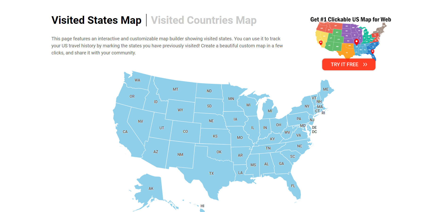
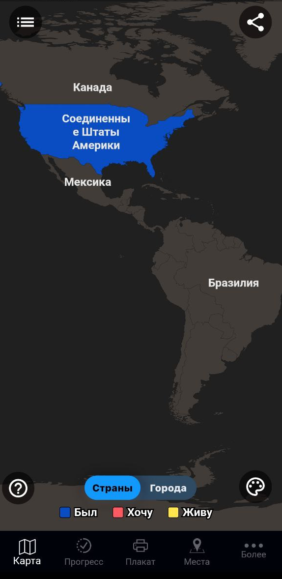
Visited States Map
This page features an interactive and customizable map builder showing visited states. You can use it to track your US travel history by marking the states you have previously visited! Create a beautiful custom map in a few clicks, and share it with your community. Also, check out our Interactive US Map for Websites with advanced customization options!


Select states you visited
- Connecticut
- District of Columbia
- Massachusetts
- Mississippi
- New Hampshire
- North Carolina
- North Dakota
- Pennsylvania
- Rhode Island
- South Carolina
- South Dakota
- West Virginia

Share the URL anywhere you want - or save it so you can come back and add new achievements to your map.
Embedding the map
If you need a US map with advanced features for your website, we offer several options for you. Alongside the standard HTML and JavaScript package, you can also opt for an easy-to-use WordPress plugin.

Frequently Asked Questions
This very simple tool allows you to easily create a map of states you have visited. Simply click on the states on the map, or toggle a checklist item below the map to mark where you have been. You can also customize the colors, turn off labels, and show stats regarding the number of states you have visited.
You can use this tool to track how many US states you have been to. In the "Set Map Parameters" control, check the "Show stats" box. The number of states where you have been will be displayed below the map. When the "Show stats" control is active, the exact number of states you have been to and the percentage of states you have visited are shown below the map.
This page features buttons that allow you to share this map via Facebook, Twitter, and Pinterest. Once you click the button, it will generate an image for the customized map and opens a new tab directing you to the social network you selected. You can also copy the URL and share it on any social network. If you opened map maker from a mobile device, use the share buttons built into your browser.
In the "Set Map Parameters" section, you will see four color options. Click on the associated color square to open the color picker. Once opened, can choose from millions of colors for the states and borders.
This can be done easily, and without the need for registration. Simply copy the unique URL and add it to your bookmarks.
You can quickly reset the map by clicking the "Clear map and reset colors" button. Note, this will reset all the states you have visited, along with reverting your color options and customized settings back to their default.
States Visited Map & Counter
Explore the united states on our interactive map! Mark, showcase and count the states you have visited.
States Visited
Traveled the US
Share the personalized map of the states you have visited:
Visualize and count the states you have visited
Use the united states map as a digital scratch map and mark all the states you have already visited with a few simple mouse clicks. Whether it was a brief city excursion, an extensive vacation, or a phase of living abroad, you can capture and visualize those experiences on this map. If you're unable to locate the states you have been on the map, the states checklist beneath it is your guide.
States Visited Checklist
The following form lists all 50 states of the United States of America. Simply select the state by checking the box, and watch as it automatically fills with color on the map. This action will also increase the states counter by one. Additionally, you can directly observe the percentage of the United States you have already traveled.
United States (50)
Countries to visit.
Have you already been to ... ? Based on your countries visited checklist above and the Most Visited Countries in the World , we have the following travel recommendations for you:
Share and Showcase your Travel Journey and Discover new Places
Explore the United States in a new and exciting way with our "States Visited Map & Counter." This interactive tool allows you to track and highlight the states you've visited, creating a personalized visual representation of your travels across the country. Whether you're an avid traveler or just starting to explore, our map makes it easy to document your journey. With a simple and intuitive interface, you can quickly select states by name and see them come to life with vibrant colors on the map. The "States Visited" feature enables you to effortlessly keep track of where you've been, creating a unique travel history that you can share with others. Our platform also offers a counter that tallies the number of states you've explored, giving you a clear picture of your travel milestones. Sharing your custom "States Visited Map" is easy, allowing you to inspire friends and family to embark on their own adventures. Celebrate your travel experiences and showcase your adventures with our "States I've Been To Map." Start highlighting and sharing your journey today, and create a lasting memory of the states you've explored across the USA.
United States: Key Facts and Travel Highlights
The United States is made up of 50 states, each with its own unique identity and features. Collectively, the states encompass diverse landscapes, ranging from sunny beaches and vast deserts to towering mountains and dense forests.
- Population: The combined population of the U.S. states is approximately 331 million people, with California being the most populous state and Wyoming the least.
- Land Area: The total land area of the U.S. is about 3.8 million square miles, with Alaska being the largest state by land area and Rhode Island the smallest.
- Geographical Features: The U.S. boasts a wide variety of geographical features including the Rocky Mountains, the Great Plains, the Appalachian Mountains, and extensive coastlines along both the Atlantic and Pacific Oceans.
- Climate: The climate varies widely across states, from the temperate rainforests of the Pacific Northwest to the arid deserts of the Southwest. States like Florida and Hawaii enjoy tropical climates, while states like Minnesota and Maine experience cold winters.
- Economy: Each state contributes to the nation's economy in unique ways. For instance, California is a global hub for technology and entertainment, Texas is a leader in energy production, and New York is a financial powerhouse.
- Tourism: Major tourist attractions span across the states, including national parks like Yellowstone and the Grand Canyon, iconic landmarks like the Statue of Liberty, and popular destinations such as Las Vegas and Walt Disney World.
- Cultural Highlights: The U.S. states are rich in cultural diversity, offering a variety of festivals, historical sites, and regional cuisines. For example, New Orleans in Louisiana is famous for its Mardi Gras celebrations, while Kentucky is renowned for its bourbon and horse racing.
Exploring U.S. Travel Trends: Most and Least Visited States
When exploring travel trends across the United States, it's fascinating to see which states attract the most and least visitors, as well as how many states the average tourist tends to visit.
Most Visited State
Among the 50 states, California stands out as the most visited. Its allure is largely due to its diverse attractions and iconic landmarks. Visitors flock to California for a mix of experiences: the bustling entertainment scene of Los Angeles, the picturesque landscapes of San Francisco, and the world-famous Disneyland Resort in Anaheim. Additionally, California’s natural wonders, including Yosemite National Park and the breathtaking coastline of Big Sur, draw millions of nature enthusiasts and adventure seekers each year. The state's varied climate and geography offer something for every type of traveler, from urban explorers to beach lovers and mountain hikers.
Least Visited State
On the flip side, Wyoming is often recognized as one of the least visited states in the U.S. Despite its stunning natural beauty, including Yellowstone National Park and Grand Teton National Park, Wyoming has a relatively low population density and fewer major urban centers, which contributes to its lower visitor numbers. However, for those seeking solitude and a chance to experience some of America’s most pristine landscapes without the crowds, Wyoming offers a unique and serene travel experience.
Average State Visits
For the average American traveler, the typical number of states visited varies significantly based on individual travel habits and interests. On average, many Americans visit around 10 to 15 states in their lifetime. This number can be influenced by factors such as family vacations, work-related travel, and personal exploration. For international tourists, the trend might differ slightly. Many international visitors tend to focus on major metropolitan areas and key tourist attractions, often visiting a handful of states that offer a representative experience of American culture and landscapes.
In summary, while California’s vibrant cities and natural wonders make it the most visited state, Wyoming’s less-traveled paths provide a quieter alternative. Whether you're an American or an international traveler, the number of states visited will vary based on your travel preferences and goals.
Use this tool to create stunning interactive maps of your travels across the United States. Select the states, add animations, configure the way you see fit. Then download as a static image, embeddable code, or even a smooth video or an animated GIF. Once you're done, check out 200+ other maps we have.
Visited States + DC Map Generator

USA Travel: I've Been in US 4+
Counties map of united states, sergei shpygar, designed for ipad.
- 4.7 • 814 Ratings
- Offers In-App Purchases
Screenshots
Description.
Create your own travel map marking states & counties of USA where you've been! The app is user friendly and allows you to: - mark visited states & counties - create categories: visited, wish to visit, etc - track world heritage - keep the travel stats - pin pictures and notes for visited places - sync with the iCloud and Dropbox to restore and access the data from new devices - share your own travel map via different social media Send your feedback to e-mail: [email protected]
Version 1.5.3
- We fixed the crash on iPad - Other bugs fixed
Ratings and Reviews
814 Ratings
I love states
I really love states so bad and for Christmas I really want the first five USA flags which is Alabama, Alaska, Arizona, Arkansas, and California. The state and county I live in is mingo, West Virginia. My mom is thinking if I can go to all the states in the United States.
I like the idea of this app, it is a great tool for teaching kids geography. Would nice to be able to select multiple categories for each state, so I can work with each of my grandkids on where there have visited, (by selecting each state with a multiple catagory). Or is there a way to open multiple scenarios?
Developer Response ,
Thank you for feedback! Try to create 2 accounts-file in the Dropbox for this feature
Great app. One suggestion
For when we make county maps, usually of the whole country, can we edit the border thickness of counties and states separately? This would be helpful in seeing the state boundaries easter
In-App Purchases
App privacy.
The developer, Sergei Shpygar , indicated that the app’s privacy practices may include handling of data as described below. For more information, see the developer’s privacy policy .
Data Not Linked to You
The following data may be collected but it is not linked to your identity:
- Diagnostics
Privacy practices may vary, for example, based on the features you use or your age. Learn More
Information
- Traveler Pro $9.99
- World Heritage $0.00
- Map of Texas Counties $0.99
- Map of Hawaii Counties $0.00
- Map of New York Counties $0.99
- Map of Florida Counties $0.99
- Map of District of Columbia $0.00
- Map of Virgin Islands $0.00
- Map of California Counties $0.99
- Map of Rhode Island Counties $0.00
- Developer Website
- App Support
- Privacy Policy

Game Center
Challenge friends and check leaderboards and achievements..

Family Sharing
Some in‑app purchases, including subscriptions, may be shareable with your family group when family sharing is enabled., more by this developer.
Mark O'Travel: Where I've Been
EveryPlace - Where I've been?
Space. Cards for children.
China Travel Map: I Have Been
Marine Creatures Cards of Sea
Sounds of Farm, Wild Animals!
You Might Also Like
Photo Map - Travel Tracker
States Visited
VoyageX | Visited Countries
US States Visited
USA States - Map Tracker
Travel Pins: Track Where Been
Copyright © 2024 Apple Inc. All rights reserved.
Apps and services to keep track of visited states in the U.S
In this article, we've compiled the best services and apps to check off U.S. states visited.
Visited states map
Create your visited states map, visited states map, usa tracker, places been - travel tracker, countries been: visited places, visited: track your travels.
Apps and sites are indispensable when traveling. Facilitating navigation, finding places of interest, reviews of hotels and vacation areas - all this is the merit of modern services. But they are useful not only during the trip. For avid travelers, it's important to mark places they've been before, keep statistics and share them with friends.
Traveling to the U.S. often requires the use of separate services. After all, states or unique attractions are not displayed everywhere. To this end, many sites and apps have been created, both for simple note taking and full-fledged note taking, goal setting, etc.
Three of the most popular state counter apps are 'Places Been - Travel Tracker', 'Countries Been: Visited Places', and 'Visited: Track Your Travels'.

Convenient minimalist site to track states visited. No extra functions - only a list of visited states. It is possible to mark states with an interactive map and a table. If you put the cursor on the interactive map - it displays the name of the state.
The map can be scaled, colors and design can be changed. After creating it, you can download the picture, share it in social networks or place the link on your personal site.
- The site is not suitable for real-time tracking, it's just creating a picture as a "recap".
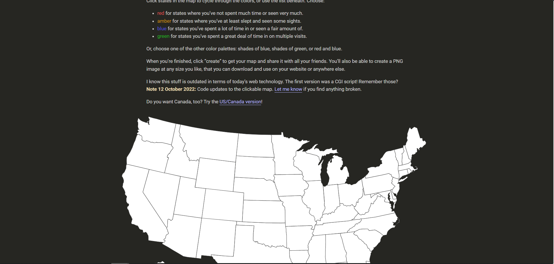
Another site for creating a map of visited states in the United States and then publishing it. Visited states are not just displayed on the map, but also marked with different colors:
- Red - have been through or haven't spent much time;
- Orange - spent at least a night;
- Blue - spent a lot of time;
- Green - spent a lot of time sightseeing or returning several times.
U.S. states not visited are grayed out.
Colors can be customized in the palette section. You can share the map by saving it in PNG format, sharing it on social media, or as a link.
The app is available in the Appstore for iOS.
- The service is not suitable for real-time tracking.
A site with a less aesthetic design than the previous ones. However, it is also capable of creating a map of visited states. You can mark a state by clicking on the interactive map or using the buttons above it. The name of the state is displayed when you hover your cursor over the map.
You can share the created map on social networks or copy it to your website. MapLoco service works not only with the U.S., but also with Europe, Asia and many other places.
A minimalistic to track states and countries visited. It has a nice blue and white palette that can be changed in the settings. Of the features - the abbreviated names of the states are marked directly on the interactive map, which facilitates orientation. When pointing the mouse you will see the full name.
You can also check off places you've visited by using the checkboxes in the list below.
- The finished map is available for downloading or posting on the site.
Mobile application to keep track of states visited for Android. After launching it, an interactive map of the USA appears, and when you click on it you can see the name of the state and its flag. The state is marked with a click on the button.
In the upper left menu you can see the "cities" section. The map will show all the cities in the United States. You can see them in more detail in zoom mode. When you click, you will see the name of the city and a caption to which state it belongs. Cities can also be marked as visited.
If it is inconvenient to mark states through the map, you can choose the section "lists" and do it through the table. However, there are no cities in the table - you only interact with them via the map.
The app keeps statistics on how many U.S. territories you've visited and how much of the world you've explored. The app also has an achievement system, such as "visit Alaska."
In the settings, you can choose a light or dark theme.
Android state counter app with more than 100 thousand downloads. Compared to previous services, the functionality here is more extensive.
The app is not only suitable for tracking travels in the U.S. states, but also around the world.
When you start it, it opens a map of the world, which displays landmarks, cities, tourist areas, etc.
The city sections have a handy search button. Visit marks are performed in different colors.
On the home page you can select a list of cities, airports, states, UNESCO attractions, etc. to display. The app also maintains statistics for the best attractions based on user reviews.
The first time you launch the state tracker app, you'll be prompted to create an account or sign in through third-party services. It is not necessary to do this, but it is recommended to prevent data loss.
The main page contains a 3D model of the Earth, which you can rotate and zoom in on. The names of countries do not appear when zooming in, but you can read the information using the button in the upper right corner. You can read information about the capital, population, etc.
The app collects statistics on the places you have visited, both countries and cities. You can download additional information about visited countries within the application itself.
If you choose the U.S., it is recommended to download the location of the states separately. The pop-up bar will help you with this.
In order to track visited states, you must register via email and also agree to be sent information. After that you have to choose a country and a city where you live, as well as previously visited countries.
After this you will be redirected to the interactive states traveled map. The countries are displayed in the following colors:
- Yellow - country of residence;
- Red - the country you want to visit;
- Blue - country you have already visited.
The app is not able to track states separately. It only involves visiting countries or cities. However, cities are only available with a paid subscription.
The app also has goals that you can meet when you visit a country from the "want to visit" list. Below are statistics on the most visited places from your country and the percentage of how many countries in the whole world you have visited.
Result: 0 , total votes: 0

I'm Vladimir, your guide in the expansive world of technology journalism, with a special focus on GPS technologies and mapping. My journey in this field extends over twenty fruitful years, fueled by a profound passion for technology and an insatiable curiosity to explore its frontiers.
Please note that creating presentations is not supported in Internet Explorer versions 6, 7. We recommend upgrading to the latest Internet Explorer, Google Chrome, or Firefox. If you are using IE 8 or later, make sure you turn off "Compatibility View".
Map of Visited States
Visited states map.
Create a color state map to show where you have travelled in the USA. Create a New USA Map

Copy and Paste Image URL:
Copy and Paste Web Page URL:
While You Are There
Official websites use .gov A .gov website belongs to an official government organization in the United States.
Secure .gov websites use HTTPS A lock ( A locked padlock ) or https:// means you’ve safely connected to the .gov website. Share sensitive information only on official, secure websites.
- Search ITA Search

US States & Cities Visited by Overseas Travelers
Most popular u.s. states and cities among international tourists.
The National Travel and Tourism Office’s U.S. States & Cities Visited Monitor is a data visualization tool highlighting overseas visitation to U.S. states and cities through interactive tables and maps. It is broken up into six helpful sections dedicated to providing intelligence and insights on the international travel industry:
- Top 5 States and U.S. Cities: volume, gains, and declines.
- Select a U.S. State: state rank, volume, # change, % change, market share, and top cities-MSAs.
- Map of Top States-Cities-MSAs: interactive display of top cities-MSAs visited in each state.
- Top U.S. States Visited: table of rank, market share, # change, % change, visitation, and market share.
- Top U.S. Cities-MSAs Visited: table of 2022 rank, market share, # change, % change, and 2022 visitation and market share.
- Excel data downloads are available.
Explore the data visualization for insights into international tourism market statistics and trends across the United States.

Discover the faces behind our amazing research team!

Have a question or need assistance? Reach out to our team and we will get back to you as soon as possible.

How Many States have You Visited?
One of my personal goals on my ‘bucket list’ is to visit all 50 states in the US! Right now I’m at 38! That means I’m over half way and moving forward with that goal. How many states have you visited? Do you display your progress in your home?
This post includes affiliate links.

I created a quick checklist on Google Spreadsheets to help us count the states. Feel free to add your name and add up the states you have visited. Once you find your number, please share so we can all see how far along on your journey you are!
Click to access the Public State Travel Map
If the Google Spreadsheet doesn’t work for you, you can download the Word version. STATES VISITED

I get the travel bug quite naturally. My Mom and Dad just wrapped up a 21 day road trip where they hit #49! All they lack now is the state of Alaska! When I was growing up, my Mom kept a map colored in showing where I had traveled. She even recorded the date when I first visited.
Why a Number?
Many people say they love to travel but don’t know how to quantify their progress. By putting a number on how many states you have visited, you are able to see your progress. Not only does this give you bragging rights when you achieve your goal of 50, but it also helps motivate you to keep traveling and exploring our great country!
How to Display your Travels
You can use a fun scratch off map like this one to help track your family travels!

If you are looking to travel to all 50 states and need a little help from the experts, check out this free resource from a fellow blogger in the Cincinnati/Northern Kentucky area. Sign up to receive new articles at Travel 50 States with Kids and receive a free copy of the e-book How to Visit All 50 States in 12 Trips.
There are great vinyl state stickers that you can use to display your state travels!
When we were in Paducah, Kentucky last year, we had the opportunity to create a United States map on reclaimed wood . We use push pins to record our travels across the country.

How many states have you visited? I’d love to hear! Count them up and share in the comments or post over on Facebook!

Similar Posts

Learning about President Garfield

Learning about Susan B Anthony: Rochester, NY

Road Trip in Northern GA
Monument valley is closed now what, visiting the national firearms museum.

Visiting Washingtons Mount Vernon
Leave a reply cancel reply.
Your email address will not be published. Required fields are marked *
This site uses Akismet to reduce spam. Learn how your comment data is processed .
- Accessibility for screenreader
- White House
- Courts and Law
- Monkey Cage
- Fact Checker
- Post Politics Blog
- The Post's View
- Toles Cartoons
- Telnaes Animations
- Local Opinions
- Global Opinions
- Letters to the Editor
- All Opinions Are Local
- Erik Wemple
- The Plum Line
- PostEverything
- PostPartisan
- Volokh Conspiracy
- The Missing Debate
- AllMetSports
- College Football
- College Basketball
- D.C. Sports Bog
- Fancy Stats
- Fantasy Sports
- Public Safety
- Transportation
- Acts of Faith
- Health and Science
- National Security
- Investigations
- Morning Mix
- Post Nation
- The Americas
- Asia and Pacific
- Middle East
- On Leadership
- Personal Finance
- Energy and Environment
- On Small Business
- World Business
- Capital Business
- Innovations
- Arts and Entertainment
- Carolyn Hax
- Home and Garden
- Inspired Life
- On Parenting
- Reliable Source
- The Intersect
- Comic Riffs
- Going Out Guide
- Puzzles and Games
- Theater and Dance
- Restaurants
- Bars & Clubs
- Popular Video
- Entertainment
- Where We Live
- Recently Sold Homes
- Classifieds
- El Tiempo Latino
- Fashion Washington
- WP BrandStudio
- washingtonpost.com
- 1996-2016 The Washington Post
- Terms of Service
- Privacy Policy
- Submissions and Discussion Policy
- RSS Terms of Service
How many states have you been to?
Some domestic and international travelers take on visiting all 50 states as a challenge. There is even an online community, the All Fifty States Club , that celebrates and encourages people on their journey. It has two rules: You must put a foot on the ground in a state and breathe its air. (Some people even have a meal or a beer there!) Click away and see how close you are to joining the club.
[ I was determined to visit all 50 states. I soon discovered I wasn’t alone. ]
How many states have you visited?
Click or tap on the map below to count how many states you’ve been to, or click here to view the full graphic
You’ve visited 0 states and D.C.
Connecticut
District of Columbia
Massachusetts
Mississippi
New Hampshire
North Carolina
North Dakota
Pennsylvania
Rhode Island
South Carolina
South Dakota
West Virginia
More stories
The essential guide to all 59 U.S. national parks
As the National Park Service turns 100, a look at the wonders it works to preserve.

Why you should visit Columbus, Ohio
The country’s 15th largest city, chock full of creativity and innovation thanks to an influx of youthful residents, gives up its secrets

Looking for a geographic thrill? Go where states meet.
The convergence of three state borders, or tri-points, offers a chance for out-of-the-way exploring.
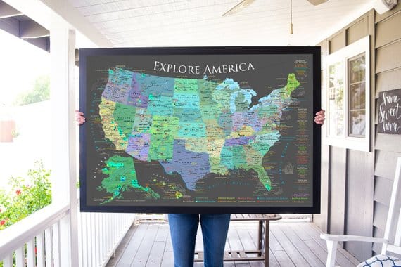
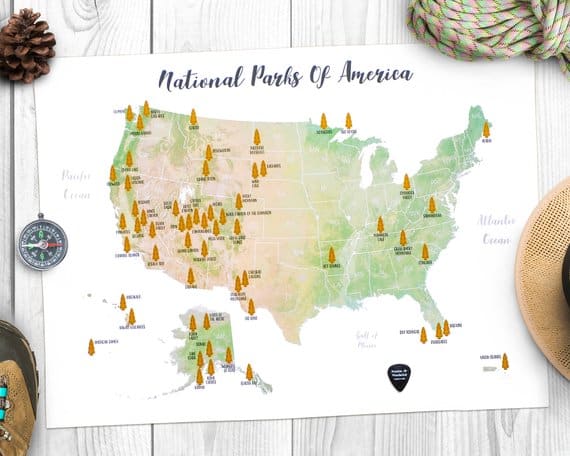
Epic US National Park Wall Maps to help you keep track of your travels
Jennifer melroy.
- Last Modified May 29, 2021
- First Published on October 13, 2019

This post may contain affiliate links, meaning if you book or buy something through one of these links, I may earn a small commission at no extra cost to you! Read the full disclosure policy here
It doesn’t matter if you have just started your US national park journey or are half-way thru with it, everyone needs a national park map to hang on your wall. A national park wall map can help you track your progress thru the parks. Or it can encourage you to plan your next national park adventure. I have always had a national park map on my wall. I love getting to check park visits off. Here are the epic United States national park wall maps from around the web.
The maps come in a range of sizes, colors, and styles. You can find a national park map to fit any room. Personally, I like hanging a national park map in my office (National Park Obsessed HQ) and one in my bedroom. I am in the process of reaching out to each of these map creators to see if they are updating them to include the 61st national park.
National Park Map Prices
My favorite national park maps, us national parks checklist board, national park pushpin maps, national park checklist maps, national park scratch off maps, national park maps posters, national park wood wall map.
US National Park Wall Maps
National park map – black and white edition – usa travel map, created by a professional geographer.
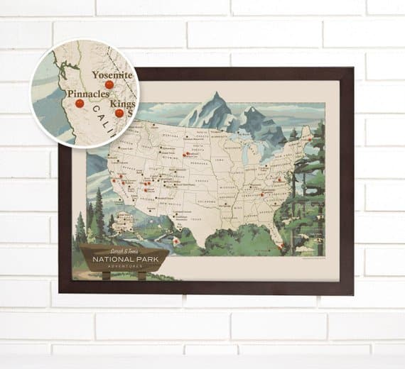
Geojango Maps is an incredibly detailed map of the United States National Park system . It features National Parks, Historical Parks, Historical Sites/Parks, National Monuments, Battlefields, Lakeshores, Preserves, and other fascinating destination spots preserved for our nation. This pushpin map is available in a range of sizes to fit any wall space.
Read my detailed review of this amazing map .
Price Range: $$
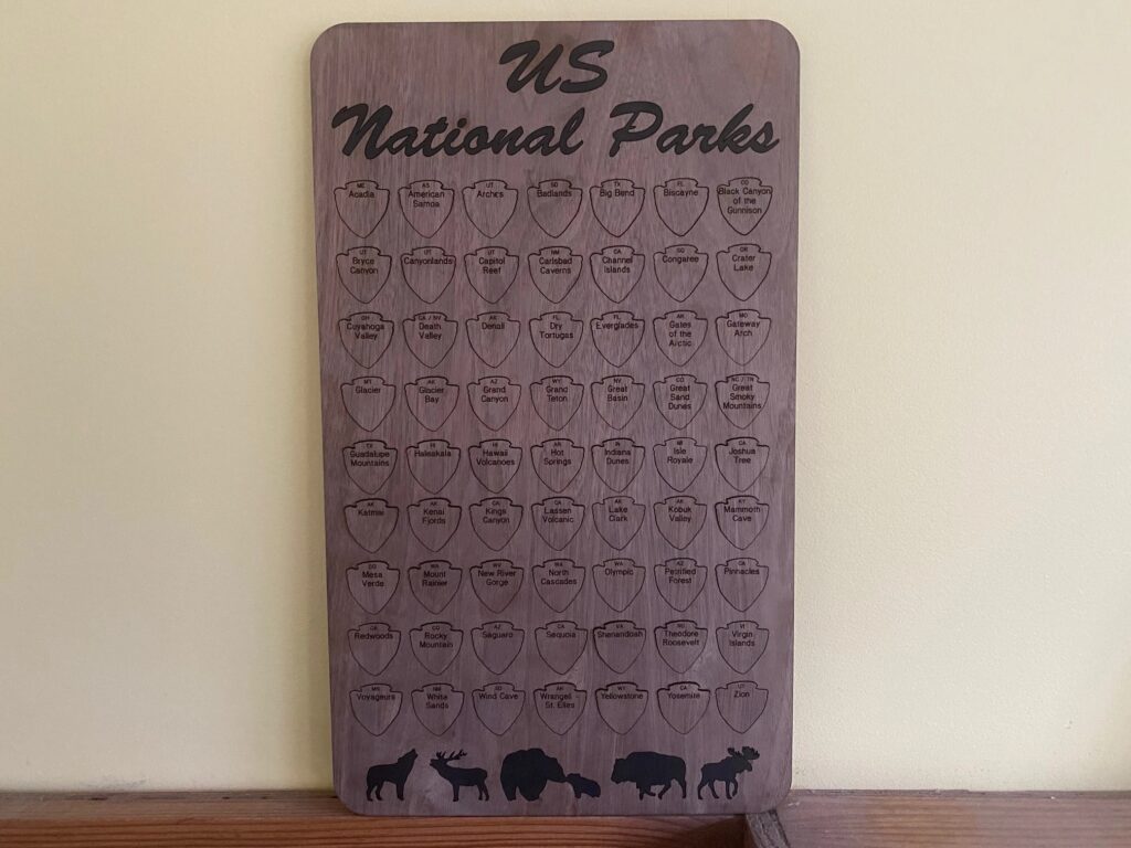
This wood checklist board is laser cut and handmade by Jennifer of National Park Obsessed. The National Park Checklist tracker comes with 63 engraved tokens. One for each national park. Each token features the name of the park and the state(s) that the park is located in. You can track your park visits in the order you visit them or alphabetically. Track your progress any way you would like.
Available in Birch, Cherry, Mahogany, Red Oak, Walnut, White Oak.
World Vibe Studio Pushpin National Park Map
World Vibe Studio has a wood grain pushpin map with space to pin your own photos. The matte paper is mounted on foam making it perfect to use pushpins to mark your progress thru the national parks and national monuments. The map comes in the following sizes: 18″ by 42″ and 22″ by 56″. The map has all 61 National Parks and a selection of other national park service units. The map can be personalized with your name.
Price Range: $$$$

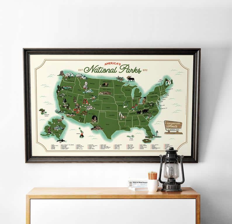
Wendy Gold Personalized Pushpin USA National Parks Travel Map
Wendy Gold’s offers a framed national park travel map of the 61 US National Parks. The map is personalized with a national park sign with your name on it. The maps is mounted to a foam core and comes with 100 pins to mark your progress. The map comes in the following sizes: 18″ by 24″, 22″ by 28″, and 24″ by 30″ and you can pick your frame color.
World Viber Studio Pushpin National Park Map
World Vibe Studio has a wood grain pushpin map. The matte paper is mounted on foam making it perfect to use pushpins to mark your progress thru the national parks. The map comes in the following sizes: 20″ by 30″, 24″ by 36″, and 30″ by 45″. The map has all 61 National Parks and a selection of other national park service units. The map can be personalized with your name.
Price Range: $$$

Happy Place Art’s National Park Map
Happy Place Art offers a green watercolor national park map. The map is the best of several worlds. The map can be customized with your name and provides a national park checklist. Please confirm with the shop owner that the map has 61 National Parks on it. The listing photos haven’t been updated to include it.
The map can be ordered as a Digitial File, a range of sizes printed on canvas or photo paper or as a pushpin map.

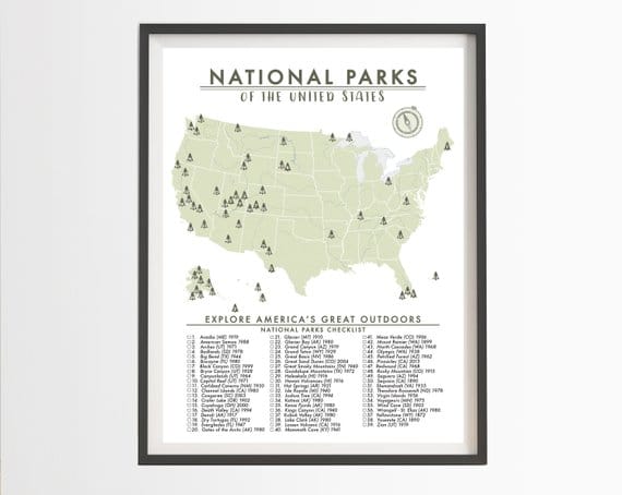
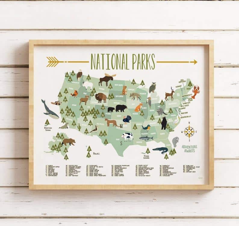
AnAdventureAwaits National Parks Map of the United States – Parks Checklist
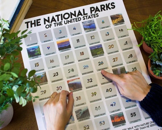
An Adventure Awaits ‘s has a National Parks Map of the United States Checklist. The print is offered in various sizes from 11″ by 14″ and 40″ by 60″. The map is printed on premium quality matte photo paper. The checklist has all 61 National Parks and the year the park is found.
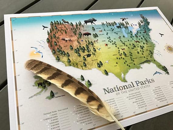
Treehouse Modern’s National Park Checklist Map
Treehouse Modern offers a detailed map featuring North American wildlife, mountain ranges, rivers, and valleys. The print is offered in 12″ by 18″ or 16″ by 20″ size. The map is a work of art and more than just a map with a checklist. The checklist has space to add the year you visited the park. The map has 61 parks on it.
Price Range: $
Printable Adventure Awaits US National Park Map
Peach on the Table ‘s Printable US National Park Map is an instant download for a national park checklist map. This map features all 61 US national parks along with the state borders, capitals and major cities. The map can be printed up in the following sizes – 36″ x 24″, 24″ x 18″, 20″ x 16″, A1
iPrint Art’s National Park Map is perfect for the junior ranger in your life. This map is a digital download and the download comes with 3 different sizes 16″ by 20″, 18″ by 24″, and 24″ by 36″. The map has a whimsical version of the North American wildlife. The map has the 60 National Parks and a checkbox for the junior rangers to mark off their progress.
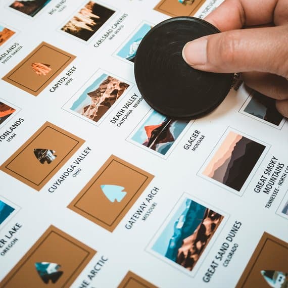
The National Parks Scratch Off Travel Print by Mappinner
Mappinners ‘ National Parks Scratch Off Travel Print isn’t your typical National Park map. It is an illustrated poster. Every time you visit a park, you get to scratch off the gold foil and reveal a unique illustration of that park’s most iconic spot. This scratch offprint is 16×20. This print has all 61 national parks.
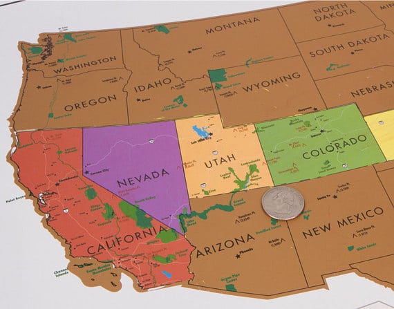
Travel Corner’s 17×24 USA Map poster with all 59 national parks
Travel Corner offers a 17×24 scratch-off map with a hanger. This small map is full of details. 59 parks are shown on the gold foil as well as highlighted by the bright colors underneath. The map features the interstates, highways, and rivers. This map is perfect to scratch off your road trips through the national parks.
** An update is in the works to include the 60th and 61st national park. They don’t currently have a date for it will be released.
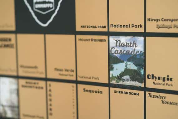
Unmapped’s National Parks Scratch Off Poster
Unmapped’s National Parks Scratch Off Poster is a 16.5″ x 12″ poster. It has the 61 National Parks in colorful squares. As you mark off your national park adventures, you scratch off the foil and reveal an art-deco piece of art. Unmapped is currently working on an update to include the two newest national parks. This is expected to be released sometime this summer.
Massive Wanderlust’s Scratch-off your National Parks Adventures!
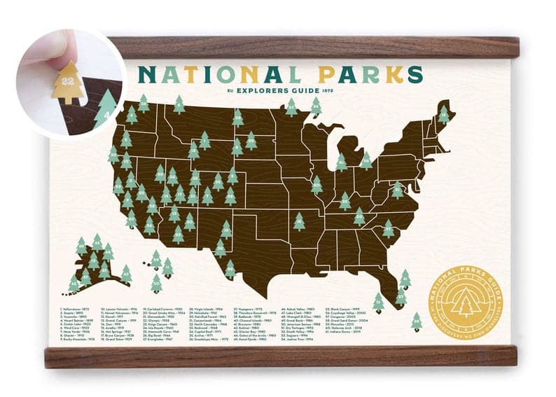
Massive Wanderlust has a National Park Adventure Map. The map has all 61 US National Parks. Each park is marked with a gold tree. Once you have visited the park, use the guitar pick to scratch off the gold foil to reveal a bright green tree. Each map is printed on museum quality paper. The map is available in a range of sizes including 18″ x 24″ and 17″ x 23″, and 23.5″ by 17″.
Scratch Off National Park Poster
The Modern Natives ‘ Scratch Off National Park Poster is 16″ by 20″. The poster is printed on high-quality art paper. Each park is covered by silver foil. As you visit each national park, you scratch off the foil and reveal a photo of the park and a unique park motto. This poster has all 60 national parks.
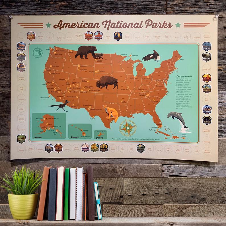
61 National Parks Map Travel Poster by Anderson Design Group
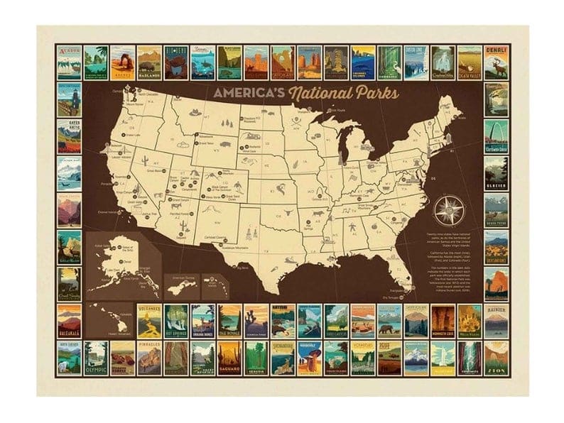
Anderson Design Group’ s National Parks Map with Travel Posters takes Anderson’s classical National Park Posters and uses them as the border for a map of the United States National Parks. The border and map feature all 61 National Parks. The map comes in a range of standard poster sizes from 8X10 to 36X48. The map is printed on 80# paper.
National Park Map
National Park Art has created an antique-looking push pin map with all of the National Park Service Units. The maps come in a range of sizes and feature 417 units. It is available in a canvas and pushpin version as well.

Lone Bison’s Illustrated National Park Map Poster
Lone Bison Good ‘s has made this illustrated map of the US National Parks. All 61 national parks are illustrated on the map. The illustrations are in mid-century style and feature iconic images of our parks. The map comes in a range of sizes. This cute map comes three different versions – poster, pushpin map, and canvas.
The National Parks Register
Wanderwide’ s National Parks Register isn’t a national park map but it a great national park poster to help you track your national park journey. It has all 61 National Parks. Each park has a cute line drawing of an iconic feature of the park. The map comes with a stamp to mark off which parks you have been to. This park can come with a frame. It is 15.5″ by 40″
**I purchased the 59 National Park version with the minimalist frame for myself in 2015. Wanderwide has gifted me with an updated version in 2019.

National Parks Sticker Map Travel Poster
The Anderson Design Group offers a 30″ by 21″ map of the national parks with a border for their national park emblem stickers. The map comes with all 61 national park emblem stickers along with 11 wildlife stickers. The map is printed on a double-laminated 80 lb paper with a matte finish.
National Parks Multi-Color Giclee print with Tree stickers
Ello There’s National Parks Multi-Color Giclee print with Tree stickers is an 11×17 map. This map does not include Gateway Arch. The standard map comes with stickers to mark off your travels. The print is printed on cream 110lb archival stock paper. This print has the option of coming framed. It comes with all 61 National Parks marked.
Amber Lodge Handcraftd National Parks of the US Wood Map
Amber Lodge Handcraftd has a handcrafted map of the 61 National Parks with the name and the location marked on a wood map. The map is offered in the following sizes 14.5″ by 15″, 17″ by 18″, and 22″ by 23″. The map is made of two-toned layered wood.
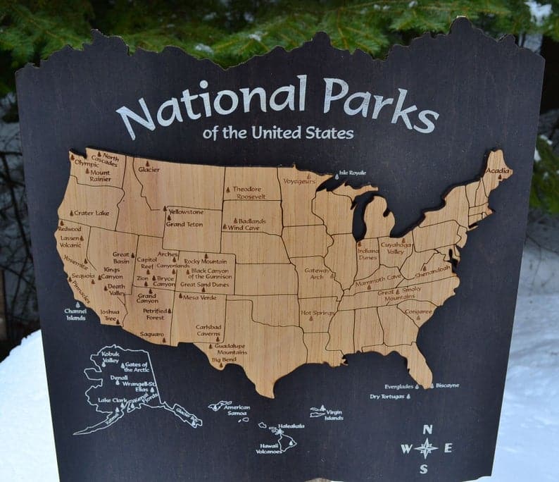
Cedar + Hide United States National Park Map
Cedar + Hide makes cedar National Park wall map. The map is 25″ by 18″. This map currently has 59 National Parks on it. It can be updated to include Gateway Arch National Park. The map is laser engraved with a walnut frame. It is a simple but elegant map.

Which National Park Wall Map is hanging on your wall?

Ryan K Biddulph
What a cool idea Jennifer. Fun way to track your travels.

Thanks. I love travel maps

Thanks for sharing this list. I love national parks maps and checklist posters. My favorite maps are from Best Maps Ever.
Hi, I'm Jennifer!

Welcome to the wonderful world of National Parks. I'm here to help you plan your NEXT amazing adventure through the United States National Parks and beyond. I want the national parks to be accessible to all.
I live in Tennessee, and when I'm home, you can find me hiking in the Smokies and the Cumberland Plateau.
58/63 National Parks
250+/423 National Park Units
Want to know more? Start Here.
Explore More
Snag one of my national park ebooks and downloadable itineraries.

Talk with an Expert

Share your love of the parks with a shirt, ornaments, hoodies, frames, and more.

ACKNOWLEDGEMENT OF LAND
On this site, we promote travel to the United States and beyond that are the traditional lands of Indigenous and First Nations peoples.
With respect, I make a formal land acknowledgment, extending my appreciation and respect to these lands’ past and present people.
To learn more about the people who call these lands home, I invite you to explore Native Land .
National Park Obsessed assumes no responsibility or liability for any errors or omissions in the content of this site (NationalParkObsessed.com). The information contained in this site is provided with no guarantees of completeness, accuracy, usefulness or timeliness. You are encouraged to conduct your own due diligence before acting on the information provided on this site and should not rely on the opinions expressed here.
There is an inherent risk in all outdoor recreation activities, the reader assumes all responsibility for their own personal safety.
We are a participant in the Amazon Services LLC Associates Program, an affiliate program designed to provide a means for us to earn fees by linking to Amazon.com and affiliated sites.
Privacy Policy • About Us • Contact
Select stock photography provided depositphotos
Copyright ©2023 National Park Obsessed, LLC
Privacy Overview
Last Updated on 29 May 2021 by Jennifer Melroy
The Most Visited States In The United States
This post may contain affiliate links. As an Amazon Associate, we earn from qualifying purchases.
Every U.S. state has many and various tourist attractions . However, specific U.S. states have become more popular traveler destinations. The following ten states are the most visited in the United States: California, Florida, Nevada, Texas, New York, Virginia, South Carolina, Arizona, Georgia, Hawaii. These U.S. states are some of their particular attractions, and their features are accented below.

1. California
California is the country’s most populated state and is a significant agricultural state, providing about 99% of some crops.
About 50% of the state’s area is government-owned and committed to the conservation of nature. Millions of travelers crowd to California to visit the national monuments, historical places, parks, and beaches. California’s most popular tourist destinations are Disneyland, which is visited by almost 15 million people annually. Other popular attractions in the state are:
- Yosemite National park.
- Death Valley.
- Disneyland.
- The Golden Gate Bridge.
- The Hollywood sign.
Disney World is the most-visited theme park globally, so it isn’t unexpected that Florida would stand so high. There’s so much else to view in Florida, including great beach cities along the Mexican Gulf and Atlantic shores. Florida is scattered with traveler attractions and historical places, recreational facilities, and excellent picturesque spots for travelers to visit.
Nevada is the place to one of the most visiting and entertaining centers globally, Las Vegas. In the city are located gambling and entertainment spots as well as the outstanding clubs in the U.S. Other famous attraction places include Lake Tahoe, Hoover Dam, Valley of Fire State Park.
Texas is the second-largest after Alaska state in the U.S. This state is genuinely distinct in all ways, shapes, and forms. Texas’s landscape varies from sands to stunning shores to mountain areas to dense woods.
5. New York
We are pretty astonished to observe New York come in as the 5th most visited state in the U.S., given how well-known its famous traveler attraction sites are. The most visited attractions of the world’s financial capital are the Empire State Building, Times Square, the National Monument of the Statue of Liberty, the Museum of Modern Art, and the Metropolitan Museum of Art.
6. Virginia
From its gorgeous rolling hills to its vibrant colonial past, Virginia has much to offer everyone passing through. Virginia stretched from the Chesapeake Bay to the Appalachian Mounts. Whether you are a beach person or mount person, Virginia is your best choice.
Famous vacationist attractions include Busch Gardens, Luray Caverns, the Shenandoah National Park, Shenandoah Valley, and different historical monuments, including preserved colonies.
7. South Carolina
South Carolina is a U.S. state of forests, beaches, and beautiful parks and gardens. If you want a pleasant, quiet holiday, think of visiting the Magnolia Plantation and Gardens, Joe Riley Waterfront ParkSkywheel Myrtle Beach, Broadway at the Beach, the Congaree, and Brookgreen Gardens.
Arizona waterfalls are at #8 in our listing of the most visited U.S states. One of the most famous tourist attraction scenes worldwide – Grand Canyon National Park, located in Arizona. Millions of tourists make their route to the state to tour this incredible natural formation. Other astonishing places such as Petrified Forest National Park, Antelope Canyon, Saguaro National Park, Monument Valley, and Petrified Forest bring millions of travelers worldwide.
Visitors to Georgia adore many tourist attractions, including Lookout Mountain, Atlanta Botanical and Rock City Gardens, Carter Presidential Library, National Center for Civil and Human Rights. Moreover, Georgia is perceived as a peach state and is essential for being the prime raiser of pecans, peanuts, and Vidalia onions.
Hawaii is a unique U.S. state located in the tropics. The state is called by many a paradise on Earth because of the picturesque landscapes, lush rainforests, waterfalls, and world-class hotels dispersed throughout the islands. Besides the forests and beaches you can visit, a dormant volcano, and an iconic landmark, Hawaii Volcanoes National Park, Waimea Canyon State, and Na Pali Coast State Park.
The Most Visited U.S. States
The least visited u.s. states.
Now that we know which U.S. states do the most visiting, it is interesting to find out which states did the least traveling. Whether they don’t have any promoted attractions or they favor spending their money on other tasks, or don’t have as much access to huge airports, these are the states who travel the least in America. Coming in at #51 is West Virginia, which is followed on the list by Vermont, Nebraska, New Hampshire, and rounding out the below five is Rhode Island. At #46, we have Kansas, then Arkansas at #44, preceded by Maine, North Dakota, and Connecticut.
Want to learn more about unique landmarks and various tourist attractions in every U.S. state? Then have a look at the following books:
- National Geographic Road Atlas
- Fodor’s Best Road Trips in the USA
Explore the world from the comfort of your home with our curated selection of cartographic treasures. Discover detailed World Atlases , eye-catching World Map Posters , interactive Scratch Off Maps , personalized Push Pin World Maps , and elegant Globes of the World . Find these perfect companions for geography enthusiasts and travelers alike on Amazon. Enhance your space and fuel your wanderlust today.

How about the most visited states by their size or population? This basically reads as a list of states ordered by how many people live in them.

Not even close Austin
California (Population: 39,613,493) Texas (Population: 29,730,311) Florida (Population: 21,944,577) New York (Population: 19,299,981) Pennsylvania (Population: 12,804,123) Illinois (Population: 12,569,321) Ohio (Population: 11714618
Georgia (Population: 10,830,007) North Carolina (Population: 10,701,022) Michigan (Population: 9,992,427

Isn’t Michigan’s population 10 million?

This is completely incorrect information. This is a list based on population not on how many people travel there every year. Sorry but Maine is in the top ten for destination hot spots for vacationers. To be honest I wish it was closer to 44.
not even close Justin
California (Population: 39,613,493) Texas (Population: 29,730,311) Florida (Population: 21,944,577) New York (Population: 19,299,981) Pennsylvania (Population: 12,804,123) Illinois (Population: 12,569,321) Ohio (Population: 11,714,618) Georgia (Population: 10,830,007) North Carolina (Population: 10,701,022) Michigan (Population: 9,992,427
Lmfao clearly you’ve never been here during flat lander season.

so basically you read the first part about California, just the first paragraph, and called it a day?

Source or methodology please?

thats crazy

man thas crazy. va is small. i live there id know lmaoo

9 mil is small to you? also lots of tourism
- Travel Advisories |
- Contact Us |
- MyTravelGov |
Find U.S. Embassies & Consulates
Travel.state.gov, congressional liaison, special issuance agency, u.s. passports, international travel, intercountry adoption, international parental child abduction, records and authentications, popular links, travel advisories, mytravelgov, stay connected, legal resources, legal information, info for u.s. law enforcement, replace or certify documents, external link.
You are about to leave travel.state.gov for an external website that is not maintained by the U.S. Department of State.
Links to external websites are provided as a convenience and should not be construed as an endorsement by the U.S. Department of State of the views or products contained therein. If you wish to remain on travel.state.gov, click the "cancel" message.
You are about to visit:
Helene live updates: Track the storm's path as it nears Florida landfall
Helene is forecast to make landfall as a hurricane on Thursday.
A new storm -- which will strengthen into Hurricane Helene -- is taking aim at Florida, where it's forecast to make landfall along the Big Bend area as a hurricane on Thursday.
Latest headlines:
- Sep 24, 2024, 3:06 PM EDT Helene’s latest forecast
- Sep 24, 2024, 3:03 PM EDT How much rain, storm surge to expect
- Sep 24, 2024, 12:32 PM EDT Universities, schools close ahead of Helene
Biden approves Florida emergency declaration ahead of Helene's landfall
As Florida residents prepare for Tropical Storm Helene to make landfall Thursday, the White House has approved the state's emergency declaration.
President Biden's approval allows for federal assistance to supplement state, tribal and local response efforts.
The Department of Homeland Security and the Federal Emergency Management Agency (FEMA) will coordinate all federal disaster relief efforts, according to the White House's statement.
Biden's approval Tuesday comes as officials in Sarasota County announced a Level A evacuation order for portions of two neighborhoods beginning Wednesday morning at 7:00 a.m. ET.
Officials encouraged residents in Curry Creek, Hatchett Creek, Venice and those in Forked Creek, Englewood to be aware of the conditions and stay alert for further updates.
Hurricane warnings issued for portions of Florida's Panhandle, Big Bend and Gulf Coast
On the current track, Tropical Storm Helene is forecast to make landfall late Thursday night, between 8:00 and 10:00 p.m. ET, as a major Category 3 hurricane with winds up to 115 mph in the Florida Big Bend region.

Hurricane warnings have been issued for Florida's Panhandle, Big Bend and Gulf Coast regions and hurricane watch warnings have extended into southern Georgia.

Officials have issued tropical storm warnings from Naples and Fort Myers to Orlando and tropical storm watch warnings are in place across Florida's east coast up to Savannah, Georgia.
-ABC News' Melissa Griffin
Helene’s latest forecast
Helene is expected to strengthen to a hurricane on Wednesday as it enters the Gulf of Mexico and strengthen further to a major Category 3 hurricane by Thursday morning.
A hurricane watch is in effect in Florida from Tallahassee to Tampa, where hurricane conditions will be possible late Wednesday night through late Thursday night.

Wednesday night into Thursday morning, Helene’s outer bands will start to lash Florida’s Gulf Coast. The worst of the conditions will be throughout the day on Thursday.
Helene is forecast to make landfall Thursday night along Florida’s Big Bend region as a Category 3 hurricane. Winds could be up to 115 mph during landfall.

Helene is expected to be a large hurricane, which means impacts will extend significantly beyond the center, impacting most of Florida and much of the Southeast.
After landfall, Helene is forecast to quickly move north into Georgia, bringing heavy rain and strong winds to the South.
A significant flash flood risk stretches from the Florida Panhandle to South Carolina -- including Tallahassee to Atlanta -- Thursday night into early Friday.

How much rain, storm surge to expect
Ten to 15 feet of dangerous storm surge is forecast for Florida’s Big Bend area. Tampa Bay could see 4 to 8 feet of storm surge.

Four to 8 inches of rain is expected from Helene, with 12 inches locally, bringing major flash flooding.
Tornadoes are also possible on Wednesday and Thursday.
Damaging wind gusts over 100 mph will be possible in Tallahassee and Florida’s Big Bend area during landfall Thursday night.
Related Topics
Top stories.
Helene live updates: Track the storm's path as it nears Florida landfall
- 2 hours ago

Death row inmate Marcellus Williams executed by lethal injection in Missouri
- 4 hours ago

Sub expert who went on Titan dive: 'OceanGate came very, very close to killing me'
- Sep 24, 5:25 PM

Department won't provide election security after sheriff's posts about Harris yard signs
- Sep 22, 2:19 PM

Upcoming filing could contain new evidence in Jan. 6 case, following judge's ruling
- Sep 24, 3:48 PM
Hurricane watch ordered for Florida as Tropical Storm Helene moves closer
A hurricane watch and warnings of storm surges up to 15 feet were issued Tuesday for almost all of Florida's western coastline as Tropical Storm Helene formed over the Caribbean Sea and headed toward the Gulf Coast.
Helene officially formed Tuesday, the National Hurricane Center said in an 11 a.m. advisory. The storm is forecast to strengthen into a hurricane Wednesday, and authorities urge people to prepare and exercise caution.
The hurricane watch extends from Indian Pass in northwest Florida near Panama City to Englewood, and it includes Tampa Bay.
At 2 p.m. ET, the weather system was about 115 miles east-southeast of Cozumel, Mexico, with maximum sustained winds of 60 mph. It was moving northwest at 12 mph, according to the National Hurricane Center.
If it further strengthens, it will be the fourth hurricane to hit the U.S. this year.
The center of the storm is forecast to move across the northwestern Caribbean Sea through Tuesday night and over the eastern Gulf of Mexico on Wednesday and Thursday, the hurricane center said.
It could reach the Gulf Coast of Florida by Thursday. Helene could become a major hurricane, meaning Category 3 (with winds of 111 to 129 mph) or higher, by then.
Helene is forecast to produce 4 to 8 inches of rain over western Cuba and the Cayman Islands, with isolated totals around 12 inches. In the southeastern U.S., it’s forecast to produce 3 to 6 inches, with isolated totals around 10 inches, and it is likely to result in local flash and urban flooding. It’s also forecast to bring storm surge and strong tide, leading to flooding by rising waters’ moving inland from the shoreline, the hurricane center said.
Florida Gov. Ron DeSantis declared a state of emergency in 41 counties Monday, which was expanded to include 61 counties Tuesday. Sandbags were being distributed in Tallahassee and Gulfport ahead of potential flooding.
DeSantis said that he requested a pre-landfall emergency declaration from the Federal Emergency Management Agency and that President Joe Biden approved it Tuesday. DeSantis warned that prediction models range from showing the disturbance forming into a tropical storm to showing it exploding into a possible Category 4 major hurricane.
Models show the Big Bend and Panhandle areas should brace for potential direct impact, he said.
Jonathan Vigh, a meteorologist at the National Center for Atmospheric Research, said Monday on X that early data show "the highest probabilities are aimed at #Tallahassee, capital of #Florida, which has about a 45% chance that the center passes nearby."
DeSantis urged Floridians to prepare by filling gas tanks, stocking up on food, cleaning up yards to prevent strong winds from throwing debris and being familiar with evacuation zones. So far, 18,000 line operators are ready to restore power, 3,000 National Guard personnel stand ready to assist and the Florida State Guard has also been activated, along with shallow water vessels and search-and-rescue crews.
Florida A&M University, Tallahassee State College and Florida State University have called off classes and closed campuses. Hillsborough County Public Schools, in the Tampa area, also announced schools will be closed Wednesday and Thursday.
On the southeastern Gulf Coast, Sarasota County, Charlotte County and the city of St. Petersburg all declared local states of emergency.
The Sarasota County government said it will send out an evacuation alert for certain communities and manufactured home communities starting Wednesday morning. Charlotte County said evacuations have been ordered for barrier islands, low-lying and flood-prone areas and manufactured homes and residences that can't withstand powerful winds. The city of St. Petersburg said mandatory evacuation orders were issued in Pinellas County for health care and long-term care facilities in certain zones.
Hernando County , north of the Tampa Bay, also called for mandatory evacuations for areas west of U.S. Highway 19 starting Wednesday morning.
Tampa General Hospital, which has the region’s only Level I trauma center, began installing an AquaFence, set to be fully in place by Wednesday. The fence provides “a water-tight barrier capable of withstanding up to 15 feet of storm surge to protect vulnerable areas of the hospital,” the hospital wrote on Facebook.
Georgia Gov. Brian Kemp also declared a state of emergency Tuesday as a southern part of the state was put under a tropical storm watch. The executive order enables first responders to better prepare for the storm, he said.
The National Hurricane Center's forecast path has the storm moving into Georgia early Friday and over the Atlanta area by the afternoon. By then, it will have weakened from a possible major hurricane, with torrential rain as its most concerning impact, forecasters say.
National Hurricane Center Deputy Director Jamie Rhome said in a video update Tuesday that Atlanta and other parts of Georgia near the front's projected path should be "alert for potential flooding as this system moves inland."
The National Oceanic and Atmospheric Administration predicted an extremely active hurricane season, forecasting 17 to 24 named storms, eight to 13 of which could become hurricanes, including four to seven major hurricanes.
The hurricane season runs from June 1 through Nov. 30. The reasons for the high activity include warmer-than-average sea surface temperatures in the tropical Atlantic and Caribbean Sea, reduced vertical wind shear, weaker tropical Atlantic trade winds and an enhanced west African monsoon.
In the case of Helene, record warm waters will fuel intensification. According to Climate Central , exceptionally warm sea surface temperatures along the system’s projected path, through the northern Caribbean and the eastern Gulf of Mexico, have become at least 200 to 500 times more likely because of human-caused climate change. Rapidly intensifying hurricanes are becoming more common in the warmer world.
If Helene does become a hurricane, it will be the fifth to have made landfall in Florida in three years, according to the Florida Climate Center .
Marlene Lenthang is a breaking news reporter for NBC News Digital.
Kathryn Prociv is a senior meteorologist and producer for NBC News.
Dennis Romero is a breaking news reporter for NBC News Digital.
IMAGES
COMMENTS
Make your own interactive visited states map. Just select the states you visited and share the map with your friends.
Drivers, motorcycle riders, car touring enthusiasts: Create a color state map to show where you have travelled. Instructions: Check the states checklist for the states you have visited, select a map size, then click Draw Map to create your own customized map of visited states. Right-click on your customized map to copy the map or save it to ...
Visited States Map. This page features an interactive and customizable map builder showing visited states. You can use it to track your US travel history by marking the states you have previously visited! Create a beautiful custom map in a few clicks, and share it with your community. Also, check out our Interactive US Map for Websites with ...
Explore the United States in a new and exciting way with our "States Visited Map & Counter." This interactive tool allows you to track and highlight the states you've visited, creating a personalized visual representation of your travels across the country. Whether you're an avid traveler or just starting to explore, our map makes it easy to ...
visitedplaces. com. Use this tool to create stunning interactive maps of your travels across the United States. Select the states, add animations, configure the way you see fit. Then download as a static image, embeddable code, or even a smooth video or an animated GIF. Once you're done, check out 200+ other maps we have.
Visited States + DC Map Generator. Welcome to the Maploco Visited States Generator! This is a fun tool that lets you show your friends all the places you've been. Check the states (and DC) you've been to in the list below. When you're done you can use the buttons to share on Facebook, Pinterest and other sites. Share with your friends!
About Visited States Map Create Your Visited States Map. Click states in the map to cycle through the colors, or use the list beneath. Choose: red for states where you've not spent much time or seen very much.; amber for states where you've at least slept and seen some sights.; blue for states you've spent a lot of time in or seen a fair amount of.; green for states you've spent a ...
iPhone Screenshots. The US States Visited app lets you keep track of the states you have visited in the US. You can create up to 20 different maps! For each state, you can mark it as visited, rate it, and add a small description. Also, you will see the capital of the state, the estimated state population, and the state flag.
Create your own travel map marking states & counties of USA where you've been! The app is user friendly and allows you to: - mark visited states & counties. - create categories: visited, wish to visit, etc. - track world heritage. - keep the travel stats. - pin pictures and notes for visited places. - sync with the iCloud and Dropbox to restore ...
That also creates a backup of your visit. Provides summary state visit counts and details for each category. Now with zoomable maps! Pinch to zoom in and out. Use wifi or 3g to see standard, satellite and hybrid maps, and more zoom-in detail. (When network is unavailable, you will still see a standard map with state boundaries).
Three of the most popular state counter apps are 'Places Been - Travel Tracker', 'Countries Been: Visited Places', and 'Visited: Track Your Travels'. Convenient minimalist site to track states visited. No extra functions - only a list of visited states. It is possible to mark states with an interactive map and a table.
Mark Frauenfelder 2:04 pm Fri Oct 8, 2021. My daughter told me about an iOS app called Visited States Map which lets you keep track of the states you've visited in the United States. You can color ...
Travel.State.Gov CSI - United States Department of State
Visited States Map. Create a color state map to show where you have travelled in the USA. Create a New USA Map. Instructions: Right-click on your map to copy the map or save it to your hard drive. Upload your customized visited states map to your website, Facebook or anywhere! Show your friends and family where you have been!
The National Travel and Tourism Office's U.S. States & Cities Visited Monitor is a data visualization tool highlighting overseas visitation to U.S. states and cities through interactive tables and maps. It is broken up into six helpful sections dedicated to providing intelligence and insights on the international travel industry:
Keep track of the places you must visit based on interest. See famous places you have been to. ... you can use the state tracker to map all states on a United States Map. On top of it you can track other countries regions including: Australia, Canada, France, Germany, and UK to name a few. ...
I created a quick checklist on Google Spreadsheets to help us count the states. Feel free to add your name and add up the states you have visited. Once you find your number, please share so we can all see how far along on your journey you are! Click to access the Public State Travel Map. If the Google Spreadsheet doesn't work for you, you can ...
Feb. 23, 2017. Some domestic and international travelers take on visiting all 50 states as a challenge. There is even an online community, the All Fifty States Club, that celebrates and encourages ...
Peach on the Table 's Printable US National Park Map is an instant download for a national park checklist map. This map features all 61 US national parks along with the state borders, capitals and major cities. The map can be printed up in the following sizes - 36″ x 24″, 24″ x 18″, 20″ x 16″, A1. Price Range: $.
Every U.S. state has many and various tourist attractions. However, specific U.S. states have become more popular traveler destinations. The following ten states are the most visited in the United States: California, Florida, Nevada, Texas, New York, Virginia, South Carolina, Arizona, Georgia, Hawaii.
× External Link. You are about to leave travel.state.gov for an external website that is not maintained by the U.S. Department of State. Links to external websites are provided as a convenience and should not be construed as an endorsement by the U.S. Department of State of the views or products contained therein.
Kalākaua is received by Ulysses Grant during the visit of Hawaii in 1874. Due, perhaps, to the geographic isolation of the United States, the first visit by a foreign head of state did not occur until nearly one hundred years after independence, when King Kalākaua of the Kingdom of Hawaii came to the U.S. during December 1874. [4] [5] [6] This was followed, two years later, with a visit by ...
Personalized US travel map, customized family Map Travel Tracker, Framed canvas Color-In 12x12 Gift for Travel Lovers, family gift. (11) $59.99. $74.99 (20% off) FREE shipping. 50 States Bucket List Tracker - Free Personalization! - Pin Your Quest To Visit All 50 States - 50 States Checklist - US States Bucket List. (5.5k)
Track chairs are all-terrain, electric powered chairs that can be used on designated trails within the park. These chairs are available to anyone who has a need, and can help visitors explore areas of the state parks in new ways, often on trails that are not suitable for regular wheelchairs.
A new storm -- which will strengthen into Hurricane Helene -- is taking aim at Florida, where it's forecast to make landfall along the Big Bend area as a hurricane on Thursday.
A hurricane watch and warnings of storm surges up to 15 feet high were issued Tuesday for almost all of Florida's western coastline as Tropical Storm Helene formed over the Caribbean Sea and ...
Ukrainian President Volodymyr Zelensky toured a Pennsylvania ammunition plant on Sunday as he began a key visit to the United States in which he is expected to present his blueprint to defeat ...